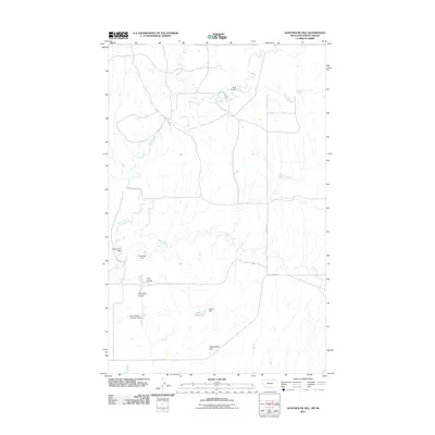
2011 Map of Lighthouse Hill
USGS Topo · Published 2011About this map
Lighthouse Hill overlooks a landscape defined by the intricate hydrology of Valley County, where water management is central to the land's utility. The drainage systems of Rock Creek and South Creek are punctuated by numerous small-scale engineering projects, including the Frank Stuber Number 1 Dam, Brown Cow Dam, and Chambers Dam. These features, along with Lake Elbert, indicate a rural economy focused on water storage and livestock in a territory marked by distinctive geographic breaks such as Line Coulee and Chambers Coulee. Transport in the early 21st century remains tied to a sparse network of local routes like Fossum Rd and Old Theony Rd, which navigate the terrain's natural contours. The map captures a moment in Montana's ranching country where family names are etched into the landscape through the dams and coulees they established.
Find a feature on this map
14 named features on this map. Tap any name to fly to it.
Don’t see what you’re looking for? This feature index may not catch every label — zoom into the map to look around manually.
Map Details
Editions of this 2011 Lighthouse Hill Map
This is the sole edition of this map. No revisions or reprints were ever made.
Other maps of this area

1919 · Boundary
USGS Topo · 1:125,000

1954 · Glasgow
USGS Topo · 1:250,000

1957 · Glasgow
USGS Topo · 1:250,000

1958 · Glasgow
USGS Topo · 1:250,000

1984 · Lighthouse Hill
USGS Topo · 1:24,000

1984 · Opheim
USGS Topo · 1:100,000

1984 · Dodge Reservoir
USGS Topo · 1:24,000

1984 · Last Chance Reservoir
USGS Topo · 1:24,000
1984 · Coal Mine Creek West
USGS Topo · 1:24,000
1984 · Thoeny
USGS Topo · 1:24,000