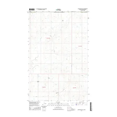
2017 Map of Lighthouse Hill
USGS Topo · Published 2017About this map
Lighthouse Hill rises as a prominent landmark in this section of Valley County, where the terrain is defined by a network of drainage coulees and ephemeral creeks. This modern survey reflects the enduring cattle-ranching landscape of northern Montana near the Canadian border, showing the remote road networks of Fossum Rd and Theony Rd that link isolated homesteads and grazing lands. The geography is marked by distinctive erosion patterns such as Chambers Coulee, First Coulee, and Line Coulee, which channel runoff toward seasonal water bodies like Rock Cr and Horse Cr. A notable hydrological feature is Lake Elbert, situated in the southern half of the quadrangle. The map also delineates the precise township and range boundaries for t37n r37e, t37n r38e, t36n r37e, and t36n r38e, which remain foundational to local land ownership and genealogy research in this sparsely populated region.
Find a feature on this map
17 named features on this map. Tap any name to fly to it.
Don’t see what you’re looking for? This feature index may not catch every label — zoom into the map to look around manually.
Map Details
Editions of this 2017 Lighthouse Hill Map
This is the sole edition of this map. No revisions or reprints were ever made.
Other maps of this area

1919 · Boundary
USGS Topo · 1:125,000

1954 · Glasgow
USGS Topo · 1:250,000

1957 · Glasgow
USGS Topo · 1:250,000

1958 · Glasgow
USGS Topo · 1:250,000

1984 · Lighthouse Hill
USGS Topo · 1:24,000

1984 · Opheim
USGS Topo · 1:100,000

1984 · Dodge Reservoir
USGS Topo · 1:24,000

1984 · Last Chance Reservoir
USGS Topo · 1:24,000
1984 · Coal Mine Creek West
USGS Topo · 1:24,000
1984 · Thoeny
USGS Topo · 1:24,000