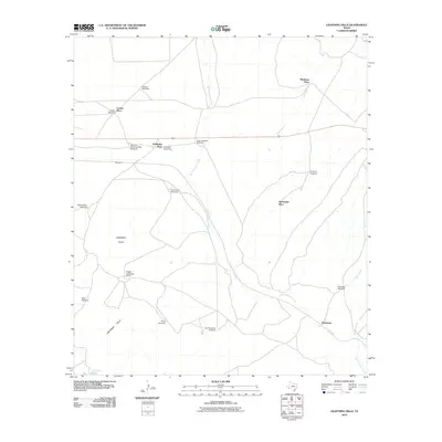
2010 Map of Lightning Hills
USGS Topo · Published 2010About this map
San Francisco Creek carves a winding path through the high desert of Brewster County, anchoring a landscape defined by isolated ranching outposts and essential water sources. This 2010 survey highlights a pattern of dispersed settlement, where family-named landmarks like Matthews Place, McFarland Place, and Kriebaum Place reveal the legacy of private land ownership in the Texas Big Bend region. The reliance on subterranean water is evident through the dense distribution of named windmills, including the Donnell Shipping Pens Windmill and Simpson Windmill, which support the livestock economy in this arid environment.
Find a feature on this map
25 named features on this map. Tap any name to fly to it.
Don’t see what you’re looking for? This feature index may not catch every label — zoom into the map to look around manually.
Map Details
Editions of this 2010 Lightning Hills Map
This is the sole edition of this map. No revisions or reprints were ever made.
Other maps of this area

1920 · Longfellow
USGS Topo · 1:125,000

1920 · Marathon
USGS Topo · 1:62,500

1921 · Marathon
USGS Topo · 1:62,500

1923 · Hess Canyon
USGS Topo · 1:62,500

1954 · Fort Stockton
USGS Topo · 1:250,000

1958 · Fort Stockton
USGS Topo · 1:250,000
1967 · Horse Mountain
USGS Topo · 1:24,000

1968 · Housetop Mountains
USGS Topo · 1:24,000

1968 · Tesnus
USGS Topo · 1:24,000

1968 · Dimple Hills
USGS Topo · 1:24,000