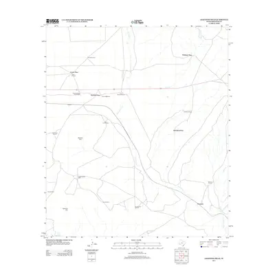
2012 Map of Lightning Hills
USGS Topo · Published 2012About this map
Haymond sits at the southern edge of this West Texas landscape, where the rail line and ranching infrastructure define the remote character of Brewster County. The topography is marked by the eponymous Lightning Hills and the neighboring Warwick Hills, while seasonal drainage is traced through the winding paths of San Francisco Cr and Frog Cr. For those researching local ranching history, the map preserves the locations of several named homesteads, including Matthews Place, Causey Place, and Kriebaum Place, which are often identified by their proximity to essential water sources like the Donnell Shipping Pens Windmill. A notable focal point is the Gages Lightning Ranch, which occupies the central western portion of the quadrangle. The presence of numerous named windmills, such as the Perez Windmill and Simpson Windmill, underscores the vital importance of groundwater management in this arid stretch of the Trans-Pecos region.
Find a feature on this map
24 named features on this map. Tap any name to fly to it.
Don’t see what you’re looking for? This feature index may not catch every label — zoom into the map to look around manually.
Map Details
Editions of this 2012 Lightning Hills Map
This is the sole edition of this map. No revisions or reprints were ever made.
Other maps of this area

1920 · Longfellow
USGS Topo · 1:125,000

1920 · Marathon
USGS Topo · 1:62,500

1921 · Marathon
USGS Topo · 1:62,500

1923 · Hess Canyon
USGS Topo · 1:62,500

1954 · Fort Stockton
USGS Topo · 1:250,000

1958 · Fort Stockton
USGS Topo · 1:250,000
1967 · Horse Mountain
USGS Topo · 1:24,000

1968 · Housetop Mountains
USGS Topo · 1:24,000

1968 · Tesnus
USGS Topo · 1:24,000

1968 · Dimple Hills
USGS Topo · 1:24,000