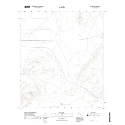
2019 Map of Lightning Hills
USGS Topo · Published 2019About this map
Blanca Springs serves as a vital water source in this arid Brewster County landscape, where the high desert terrain is defined by dramatic elevation changes. The map area is anchored by the Stillwell Mtn to the north and the namesake Lightning Hills in the southwest, separated by the winding course of San Francisco Cr. This drainage system, joined by Bragg Cr and Willow Cr, illustrates the complex topography of the Trans-Pecos region, where dry washes like Arden Draw only come alive during seasonal rains. A single artery, U.S. Highway 90, cuts across the northern half of the sheet, representing the primary connection through this sparsely populated ranching country. The proximity of the Warwick Hills further emphasizes the limestone-dominated geology that characterizes this portion of the Texas Big Bend hinterlands.
Find a feature on this map
9 named features on this map. Tap any name to fly to it.
Don’t see what you’re looking for? This feature index may not catch every label — zoom into the map to look around manually.
Map Details
Editions of this 2019 Lightning Hills Map
This is the sole edition of this map. No revisions or reprints were ever made.
Other maps of this area

1920 · Longfellow
USGS Topo · 1:125,000

1920 · Marathon
USGS Topo · 1:62,500

1921 · Marathon
USGS Topo · 1:62,500

1923 · Hess Canyon
USGS Topo · 1:62,500

1954 · Fort Stockton
USGS Topo · 1:250,000

1958 · Fort Stockton
USGS Topo · 1:250,000
1967 · Horse Mountain
USGS Topo · 1:24,000

1968 · Housetop Mountains
USGS Topo · 1:24,000

1968 · Tesnus
USGS Topo · 1:24,000

1968 · Dimple Hills
USGS Topo · 1:24,000