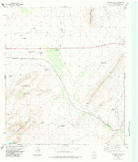
1983 Map of Lightning Hills
USGS Topo · Published 1984About this map
San Francisco Creek carves a path through this high-desert ranching landscape in Brewster County, where the infrastructure of the Southern Pacific railroad dictates the layout of remote outposts. The small settlements of Warwick and Haymond serve as primary anchors along the rail line, surrounded by the distinctive elevations of the Warwick Hills and the Lightning Hills.
Find a feature on this map
21 named features on this map. Tap any name to fly to it.
Don’t see what you’re looking for? This feature index may not catch every label — zoom into the map to look around manually.
Map Details
Editions of this 1983 Lightning Hills Map
This is the sole edition of this map. No revisions or reprints were ever made.
Other maps of this area

1920 · Longfellow
USGS Topo · 1:125,000

1920 · Marathon
USGS Topo · 1:62,500

1921 · Marathon
USGS Topo · 1:62,500

1923 · Hess Canyon
USGS Topo · 1:62,500

1954 · Fort Stockton
USGS Topo · 1:250,000

1958 · Fort Stockton
USGS Topo · 1:250,000
1967 · Horse Mountain
USGS Topo · 1:24,000

1968 · Housetop Mountains
USGS Topo · 1:24,000

1968 · Tesnus
USGS Topo · 1:24,000

1968 · Dimple Hills
USGS Topo · 1:24,000