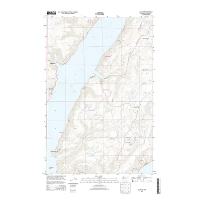
2014 Map of Lilliwaup
USGS Topo · Published 2014About this map
Hood Canal serves as the central geographic feature of this 2014 survey, dividing the waterfront settlements of Lilliwaup on the western shore from Dewatto on the eastern Kitsap Peninsula side. The landscape is defined by the sharp transition from sea level to the elevated timberlands of the Great Peninsula, where a complex network of freshwater bodies such as Aldrich Lake, Cady Lake, and Maggie Lake drains toward the sound. Along the western edge, Lilliwaup Cr descends toward Lilliwaup Bay, passing the notable Lilliwaup Falls. The distribution of shoreline features like Red Bluff, Cougar Spit, and Musqueti Point illustrates the natural coastal processes at The Great Bend. This map reflects the modern recreational character of the area, noting local infrastructure like the Rest-A-While Recreational Vehicle Park and the winding forest roads that connect these small coastal communities.
Find a feature on this map
60 named features on this map. Tap any name to fly to it.
Don’t see what you’re looking for? This feature index may not catch every label — zoom into the map to look around manually.
Map Details
Editions of this 2014 Lilliwaup Map
This is the sole edition of this map. No revisions or reprints were ever made.
Other maps of this area

1936 · Point Misery
USGS Topo · 1:62,500

1938 · Mt Constance
USGS Topo · 1:125,000

1938 · Allyn
USGS Topo · 1:62,500

1940 · Point Misery
USGS Topo · 1:62,500

1943 · Potlatch
USGS Topo · 1:62,500

1947 · The Brothers
USGS Topo · 1:62,500

1950 · The Brothers
USGS Topo · 1:62,500

1952 · Potlatch
USGS Topo · 1:62,500

1953 · Lake Wooten
USGS Topo · 1:24,000
1953 · Holly
USGS Topo · 1:24,000