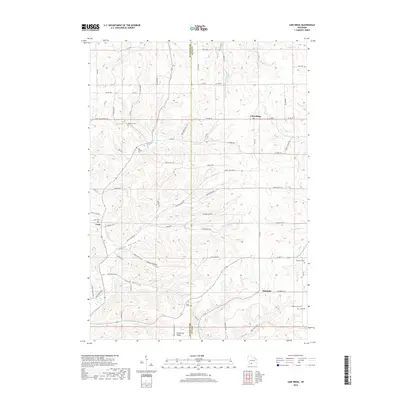
2018 Map of Lime Ridge
USGS Topo · Published 2018About this map
Lime Ridge stands as a focal point in this portion of Southwestern Wisconsin, where the landscape is defined by the winding drainages of Willow Cr and Bear Cr. The area is characterized by its numerous named hollows, including Smith Hollow, Robin Hollow, and Lost Hollow, which cut through the high ridges. These landforms influenced the development of small rural communities like Loyd and Sandusky, connected by a network of county highways and named backroads such as Smyth Hollow Rd.
Find a feature on this map
72 named features on this map. Tap any name to fly to it.
Don’t see what you’re looking for? This feature index may not catch every label — zoom into the map to look around manually.
Map Details
Editions of this 2018 Lime Ridge Map
This is the sole edition of this map. No revisions or reprints were ever made.
Other maps of this area

1905 · Richland Center
USGS Topo · 1:125,000

1927 · Hillsboro
USGS Topo · 1:62,500

1956 · Reedsburg
USGS Topo · 1:62,500

1958 · La Crosse
USGS Topo · 1:250,000

1960 · Richland Center
USGS Topo · 1:62,500

1960 · Plain
USGS Topo · 1:62,500

1961 · La Crosse
USGS Topo · 1:250,000

1965 · La Crosse
USGS Topo · 1:250,000

1966 · Hillsboro
USGS Topo · 1:62,500
1975 · Reedsburg West
USGS Topo · 1:24,000