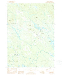
1983 Map of Limerick
USGS Topo · Published 1984About this map
Limerick and Newfield serve as the primary hubs in this York County landscape, where the Little Ossipee River dictates the settlement pattern and industrial history of the late 20th century. The waterway supported localized centers like Limerick Mills and Ossipee Mills, reflecting a traditional New England reliance on river power. Rural corners such as East Parsonsfield, Emerys Corner, and Felch Corner are connected by a network of winding roads, while local genealogy is anchored by Highland Cem and Pleasant Hill Cem.
Find a feature on this map
51 named features on this map. Tap any name to fly to it.
Don’t see what you’re looking for? This feature index may not catch every label — zoom into the map to look around manually.
Map Details
Editions of this 1983 Limerick Map
2 editions found
Other maps of this area

1891 · Buxton
USGS Topo · 1:62,500

1891 · Newfield
USGS Topo · 1:62,500

1892 · Buxton
USGS Topo · 1:62,500

1893 · Buxton
USGS Topo · 1:62,500

1893 · Newfield
USGS Topo · 1:62,500

1896 · Sebago
USGS Topo · 1:62,500

1910 · Kezar Falls
USGS Topo · 1:48,000

1911 · Kezar Falls
USGS Topo · 1:62,500

1933 · Newfield
USGS Topo · 1:48,000

1937 · Newfield
USGS Topo · 1:62,500