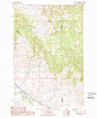
1989 Map of Limestone Ridge
USGS Topo · Published 1989About this map
Clark Fork flows through the southwestern corner of this high-country terrain, accompanied by the remnants of an Old Railroad Grade that traces the river's path. This landscape is defined by the significant elevations of Sturgeon Mountain and Campbell Mountain, separated from the eastern peaks of Saddle Mountain by the prominent Limestone Ridge. The drainage patterns of Morris Creek, Sheep Creek, and Bert Creek illustrate the complex watershed of the Granite and Powell county line. Industrial footprints are sparse but specific, including a Pumping Station near the river and a Gravel Pit located further north. This provisional survey captures the area at a time when the mountain trails and gulches like Edwards Gulch and Wisner Gulch remained largely undeveloped, preserving the character of the Montana backcountry before modern expansion.
Find a feature on this map
17 named features on this map. Tap any name to fly to it.
Don’t see what you’re looking for? This feature index may not catch every label — zoom into the map to look around manually.
Map Details
Editions of this 1989 Limestone Ridge Map
This is the sole edition of this map. No revisions or reprints were ever made.
Other maps of this area

1889 · Helena
USGS Topo · 1:250,000

1893 · Helena
USGS Topo · 1:250,000

1899 · Helena
USGS Topo · 1:250,000

1903 · Helena
USGS Topo · 1:250,000

1919 · Drummond
USGS Topo · 1:125,000

1921 · Drummond
USGS Topo · 1:125,000

1947 · Butte
USGS Topo · 1:250,000

1958 · Butte
USGS Topo · 1:250,000

1958 · Drummond
USGS Topo · 1:62,500

1958 · Garrison
USGS Topo · 1:62,500