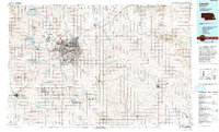
1986 Map of Lincoln
USGS Topo · Published 1994About this map
Lincoln serves as the focal point of this mid-1980s landscape, where the confluence of the Union Pacific Railroad, Burlington Northern Railroad, and Missouri Pacific Railroad underscores the city's historic role as a Midwestern transportation hub. The sprawling urban footprint is defined by the Salt Creek drainage and the nearby Municipal Airport. Surrounding the capital, a dense network of smaller agricultural communities like Waverly, Hickman, and Syracuse are connected by a grid of highways including Interstate 80 and U S Highway 77.
Find a feature on this map
137 named features on this map. Tap any name to fly to it.
Don’t see what you’re looking for? This feature index may not catch every label — zoom into the map to look around manually.
Map Details
Editions of this 1986 Lincoln Map
2 editions found
Other maps of this area

1893 · Fremont
USGS Topo · 1:125,000

1896 · Fremont
USGS Topo · 1:125,000

1897 · Lincoln
USGS Topo · 1:125,000

1899 · Wahoo
USGS Topo · 1:125,000

1899 · David City
USGS Topo · 1:125,000

1903 · Weeping Water
USGS Topo · 1:125,000

1907 · Nebraska City
USGS Topo · 1:62,500

1915 · Howe
USGS Topo · 1:62,500

1929 · Weeping Water
USGS Topo · 1:125,000

1934 · Seward
USGS Topo · 1:48,000