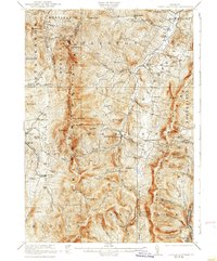
1921 Map of Lincoln Mountain
USGS Topo · Published 1938About this map
Mad River flows northward through the valley between the Green Mountains and the Northfield Mountains, anchoring a landscape of tight-knit agricultural and timber communities in the early twentieth century. This survey, conducted by Frank Sutton and his team, captures the high-elevation geography of the central ridge where the Long Trail traverses major summits including Mt Ellen, Mt Abraham, and Nancy Hanks Peak. The settlement pattern follows the river and its many tributaries, with established centers at Waitsfield, Warren, and Lincoln connected by winding roads and numerous local school districts.
Find a feature on this map
116 named features on this map. Tap any name to fly to it.
Don’t see what you’re looking for? This feature index may not catch every label — zoom into the map to look around manually.
Map Details
Editions of this 1921 Lincoln Mountain Map
5 editions found

Other maps of this area

1902 · Brandon
USGS Topo · 1:62,500

1903 · Middlebury
USGS Topo · 1:62,500

1904 · Brandon
USGS Topo · 1:62,500

1905 · Middlebury
USGS Topo · 1:62,500

1906 · Burlington
USGS Topo · 1:62,500

1915 · Rochester
USGS Topo · 1:62,500

1917 · Rochester
USGS Topo · 1:62,500

1919 · Royalton
USGS Topo · 1:62,500

1919 · Burlington
USGS Topo · 1:62,500

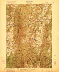
1919 · Lincoln Mountain
USGS Topo · 1:62,500