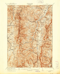
1921 Map of Lincoln Mountain
USGS Topo · Published 1944About this map
Waitsfield and Warren center this survey of the Green Mountains as they appeared during the late 1910s. The landscape is defined by the high ridge of the Long Trail, where hikers would have stopped at Battell Lodge or Proctor Lodge near the high peaks of Mt Abraham and Mt Ellen. The valley of the Mad River serves as the primary corridor for settlement, linking Irasville and Moretown through a network of rural schoolhouses such as the Robinson School and South Hill School. Notable mountain passes like Appalachian Gap and Lincoln Gap provide the only breaks in the north-south granite spine. The map records a time when the upper reaches of the Third Branch White River were home to remote encampments like Paddledock Camp, highlighting the area's transition between an agricultural valley economy and the wilder high-elevation terrain.
Find a feature on this map
106 named features on this map. Tap any name to fly to it.
Don’t see what you’re looking for? This feature index may not catch every label — zoom into the map to look around manually.
Map Details
Editions of this 1921 Lincoln Mountain Map
5 editions found

Other maps of this area

1902 · Brandon
USGS Topo · 1:62,500

1903 · Middlebury
USGS Topo · 1:62,500

1904 · Brandon
USGS Topo · 1:62,500

1905 · Middlebury
USGS Topo · 1:62,500

1906 · Burlington
USGS Topo · 1:62,500

1915 · Rochester
USGS Topo · 1:62,500

1917 · Rochester
USGS Topo · 1:62,500

1919 · Royalton
USGS Topo · 1:62,500

1919 · Burlington
USGS Topo · 1:62,500

1919 · Lincoln Mountain
USGS Topo · 1:62,500