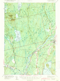
1942 Map of Lincoln
USGS Topo · Published 1942About this map
The Penobscot River serves as the central artery for this 1940s landscape, where industrial and transportation networks intersect at the confluence with the Piscataquis River. In Lincoln, the presence of Mattanawcook Stream and the Canadian Pacific railway lines highlights the importance of water power and rail transit for the region's timber and manufacturing sectors. Downstream, Howland and Enfield anchor the southern reaches, connected by the Maine Central railroad.
Find a feature on this map
86 named features on this map. Tap any name to fly to it.
Don’t see what you’re looking for? This feature index may not catch every label — zoom into the map to look around manually.
Map Details
Editions of this 1942 Lincoln Map
3 editions found
Other maps of this area

1917 · Passadumkeag
USGS Topo · 1:62,500

1920 · Winn
USGS Topo · 1:62,500

1931 · Saponac
USGS Topo · 1:48,000

1933 · Boyd Lake
USGS Topo · 1:62,500

1934 · Saponac
USGS Topo · 1:62,500

1940 · Mattawamkeag
USGS Topo · 1:62,500

1942 · Lincoln
USGS Topo · 1:62,500

1942 · Mattawamkeag
USGS Topo · 1:62,500

1947 · Schoodic
USGS Topo · 1:62,500

1949 · Schoodic
USGS Topo · 1:62,500