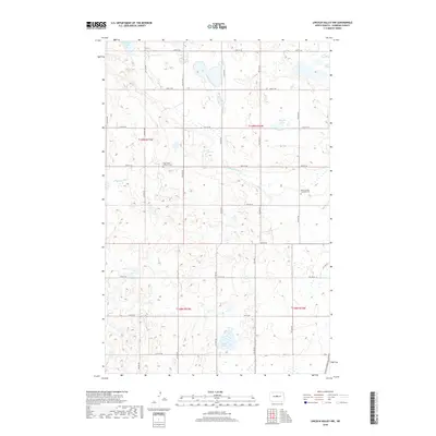
2018 Map of Lincoln Valley NW
USGS Topo · Published 2018About this map
Glacial depressions and small prairie lakes define this portion of Sheridan County, where the upper reaches of the Sheyenne River meander through a landscape dominated by the Public Land Survey System's rigid grid. The area is characterized by its agricultural layout, with roads like 23rd St NE and 15th St NE marking the section lines of Townships 148 and 149 North. This 2018 survey provides critical detail for genealogists tracing Norwegian or German-Russian heritage in the Dakotas, as it specifically identifies local landmarks of faith and remembrance including the Holy Ghost Lutheran Cem and West Scandia Lutheran Cem. Aside from these cultural anchors, the terrain is primarily natural, featuring numerous unnamed wetlands alongside named bodies like Krueger Lake, Skogmo Lake, and Bentz Lake.
Find a feature on this map
19 named features on this map. Tap any name to fly to it.
Don’t see what you’re looking for? This feature index may not catch every label — zoom into the map to look around manually.
Map Details
Editions of this 2018 Lincoln Valley NW Map
This is the sole edition of this map. No revisions or reprints were ever made.
Other maps of this area

1929 · Balfour
USGS Topo · 1:62,500

1930 · Drake
USGS Topo · 1:62,500

1945 · Pelican Lake
USGS Topo · 1:62,500

1947 · Pelican Lake
USGS Topo · 1:62,500

1947 · Lincoln Valley
USGS Topo · 1:62,500

1954 · McClusky
USGS Topo · 1:250,000

1958 · McClusky
USGS Topo · 1:250,000

1958 · Drake
USGS Topo · 1:62,500

1958 · Balfour
USGS Topo · 1:62,500
1958 · Drake SW
USGS Topo · 1:24,000