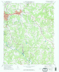
1970 Map of Lincolnton East
USGS Topo · Published 1972About this map
Lincolnton and its eastern industrial suburbs anchor this 1970 landscape, where the Seaboard Coast Line and Southern railroads converge near the South Fork Catawba River. The area shows a transition from the urban center to the textile and manufacturing communities of Boger City, High Shoals, and Long Shoals. Local infrastructure is well-defined, featuring the State Dept of Correction, County Hospital, and the Central Jr High Sch, alongside numerous neighborhood spiritual centers like Beals Chapel and Victory Grove Ch.
Find a feature on this map
46 named features on this map. Tap any name to fly to it.
Don’t see what you’re looking for? This feature index may not catch every label — zoom into the map to look around manually.
Map Details
Editions of this 1970 Lincolnton East Map
2 editions found
Other maps of this area

1895 · Hickory
USGS Topo · 1:125,000

1909 · Lincolnton
USGS Topo · 1:62,500

1911 · Lincolnton
USGS Topo · 1:62,500

1914 · Gastonia
USGS Topo · 1:48,000

1916 · Gastonia
USGS Topo · 1:62,500

1953 · Charlotte
USGS Topo · 1:250,000

1954 · Charlotte
USGS Topo · 1:250,000

1960 · Charlotte
USGS Topo · 1:250,000

1962 · Charlotte
USGS Topo · 1:250,000
1970 · Mount Holly
USGS Topo · 1:24,000