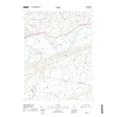
2019 Map of Linden
USGS Topo · Published 2019About this map
The West Branch Susquehanna River dominates this Lycoming County landscape, carving a wide valley between the steep slopes of Bald Eagle Mountain and the dissected uplands to the north. Settlement patterns follow the river and its tributaries, with the village of Linden situated near the river’s north bank while Antes Fort and Level Corner occupy the fertile bottomlands near Long Island and Crane Island. The southern portion of the map is defined by small, valley-bound communities like Oval, Oriole, and Collomsville, which are tucked along the base of the mountain range. Genealogists will find several burial sites throughout the townships, including the Saint Peter's Lutheran Church Cem and the Gibson Farm Plot Cem. Aviation history is also present through both the Jersey Shore Airport and the smaller Hinaman Acres Airport, reflecting the region’s varied transportation infrastructure at the end of the 2010s.
Find a feature on this map
116 named features on this map. Tap any name to fly to it.
Don’t see what you’re looking for? This feature index may not catch every label — zoom into the map to look around manually.
Map Details
Editions of this 2019 Linden Map
This is the sole edition of this map. No revisions or reprints were ever made.
Other maps of this area

1921 · Williamsport
USGS Topo · 1:48,000

1921 · Trout Run
USGS Topo · 1:62,500

1921 · Lock Haven
USGS Topo · 1:62,500

1923 · Lock Haven
USGS Topo · 1:62,500

1923 · Trout Run
USGS Topo · 1:62,500

1923 · Williamsport
USGS Topo · 1:62,500

1935 · Waterville
USGS Topo · 1:24,000

1937 · Waterville
USGS Topo · 1:48,000

1943 · Waterville
USGS Topo · 1:62,500

1944 · Trout Run
USGS Topo · 1:62,500
Featured Places
- Bastress Township, PA
- Woodward Township, PA
- Susquehanna Township, PA
- Mifflin Township, PA
- Pine Run, Woodward Township