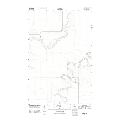
2013 Map of Lindford
USGS Topo · Published 2013About this map
The meandering Big Fork River carves a deep, winding path through this northern Minnesota landscape, meeting the smaller Black River as it flows toward the Canadian border. The small settlement of Lindford serves as the focal point for this rural Koochiching County area, situated near a sharp bend in the river. Local genealogy and history are anchored by two distinct burial grounds: the Lindford Cem located near the town center and the more isolated Lindford Township Cem to the southwest. The map reveals a sparse network of township roads and utility routes, such as Black River Rd and Co Hwy-1, which provide access through the wetlands and forests that characterize this portion of the Rainy River basin. The intricate river loops and oxbows show a landscape defined by seasonal water movement and the remote character of the borderlands.
Find a feature on this map
15 named features on this map. Tap any name to fly to it.
Don’t see what you’re looking for? This feature index may not catch every label — zoom into the map to look around manually.
Map Details
Editions of this 2013 Lindford Map
This is the sole edition of this map. No revisions or reprints were ever made.
Other maps of this area

1919 · Pelland
USGS Topo · 1:62,500

1919 · Happy Land
USGS Topo · 1:62,500

1943 · Lindford
USGS Topo · 1:62,500

1954 · International Falls
USGS Topo · 1:250,000

1957 · International Falls
USGS Topo · 1:250,000

1958 · International Falls
USGS Topo · 1:250,000

1970 · Devlin
USGS Topo · 1:24,000

1970 · Littlefork SW
USGS Topo · 1:24,000
1970 · Lindford SW
USGS Topo · 1:24,000
1970 · Lindford
USGS Topo · 1:24,000