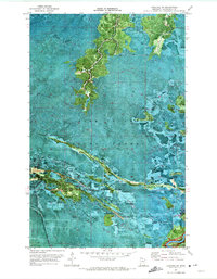
1970 Map of Lindford SW
USGS Topo · Published 1973About this map
Pine Island State Forest dominates this landscape in northern Minnesota, as recorded in this 1970 orthophotomap. The terrain is defined by a dense network of seasonal access routes, most notably the Winter Trail systems that crisscross the lowlands, reflecting a landscape adapted for cold-weather transit and resource management. In the southeastern corner, the Big Fork River cuts through the forest, serving as a primary focal point for activity. Along its banks, the Ben Linn Campground Landing provides river access, while the interior is marked by sites like Hendrickson Camp. This survey uses an aerial photographic base to distinguish between various types of forest cover and drainage patterns, offering a precise view of the northern wilderness before modern infrastructure further altered the region's character.
Find a feature on this map
5 named features on this map. Tap any name to fly to it.
Don’t see what you’re looking for? This feature index may not catch every label — zoom into the map to look around manually.
Map Details
Editions of this 1970 Lindford SW Map
This is the sole edition of this map. No revisions or reprints were ever made.
Other maps of this area

1919 · Lundgren
USGS Topo · 1:62,500

1919 · I
USGS Topo · 1:62,500

1919 · Margie
USGS Topo · 1:62,500

1943 · Lindford
USGS Topo · 1:62,500

1954 · Roseau
USGS Topo · 1:250,000

1954 · International Falls
USGS Topo · 1:250,000

1957 · Roseau
USGS Topo · 1:250,000

1957 · International Falls
USGS Topo · 1:250,000

1958 · International Falls
USGS Topo · 1:250,000

1958 · Roseau
USGS Topo · 1:250,000