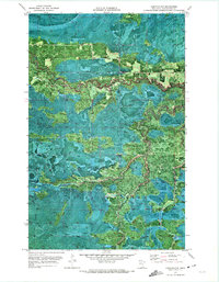
1970 Map of Lindford NW
USGS Topo · Published 1973About this map
The Pine Island State Forest dominates this northern landscape, where the meandering course of the Black River carves through dense Minnesota timberland. This 1970 orthophotomap provides a rare aerial-visual synthesis, showing the exact vegetation patterns and drainage of the region south of the Red Lake Indian Reservation. The presence of the Winter Trail highlights the seasonal nature of transportation in these wetlands, where heavy equipment and vehicles likely relied on frozen ground for access. A solitary Radio Tower stands as a rare vertical landmark in the otherwise undeveloped terrain. The map captures a moment when resource management and forestry defined the use of these vast public lands, with clear delineations between township boundaries like T. 158 N. and T. 157 N. cutting through the wilderness.
Find a feature on this map
6 named features on this map. Tap any name to fly to it.
Don’t see what you’re looking for? This feature index may not catch every label — zoom into the map to look around manually.
Map Details
Editions of this 1970 Lindford NW Map
This is the sole edition of this map. No revisions or reprints were ever made.
Other maps of this area

1919 · Birchdale
USGS Topo · 1:62,500

1919 · I
USGS Topo · 1:62,500

1943 · Lindford
USGS Topo · 1:62,500

1954 · Roseau
USGS Topo · 1:250,000

1954 · International Falls
USGS Topo · 1:250,000

1957 · Roseau
USGS Topo · 1:250,000

1957 · International Falls
USGS Topo · 1:250,000

1958 · International Falls
USGS Topo · 1:250,000

1958 · Roseau
USGS Topo · 1:250,000

1968 · Birchdale SE
USGS Topo · 1:24,000