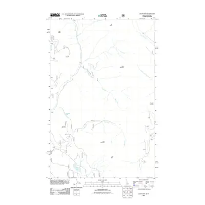
2011 Map of Line Point
USGS Topo · Published 2011About this map
Solomon Lake and Perkins Lake sit within a landscape of drainage networks and high ridges in this 2011 survey of Lincoln County. The area is defined by the convergence of several waterways, including Mill Creek, Faro Creek, and Hellroaring Creek, which carve through the terrain between prominent peaks like Solomon Mountain and Goat Mountain.
Find a feature on this map
28 named features on this map. Tap any name to fly to it.
Don’t see what you’re looking for? This feature index may not catch every label — zoom into the map to look around manually.
Map Details
Editions of this 2011 Line Point Map
This is the sole edition of this map. No revisions or reprints were ever made.
Other maps of this area

1911 · Priest Lake
USGS Topo · 1:250,000

1913 · Priest Lake
USGS Topo · 1:250,000

1957 · Kalispell
USGS Topo · 1:250,000

1958 · Sandpoint
USGS Topo · 1:250,000

1960 · Kalispell
USGS Topo · 1:250,000

1961 · Kalispell
USGS Topo · 1:250,000

1963 · Sandpoint
USGS Topo · 1:250,000

1963 · Mount Baldy
USGS Topo · 1:24,000

1963 · Northwest Peak
USGS Topo · 1:24,000
1963 · Newton Mountain
USGS Topo · 1:24,000