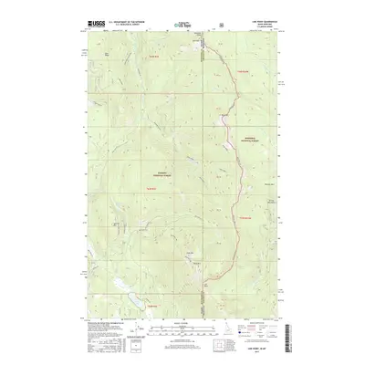
2017 Map of Line Point
USGS Topo · Published 2017About this map
Kaniksu National Forest and Kootenai National Forest converge along the state border in this high-elevation survey of the Purcell Mountains. The landscape is defined by the sharp divide of the Montana Line, where Boundary County, Idaho, meets Lincoln County, Montana. This borderland territory is traversed by forest service routes like Skin Creek Rd and Buckhorn Mtn Rd, providing access to remote peaks including The Scout, Keno Mtn, and Thunder Mtn. Water drainage is complex, with Solomon Lake feeding into Solomon Cr and the larger Perkins Lake situated to the south. The presence of the namesake Line Point settlement area at the junction of state and county boundaries reflects the era's reliance on forestry access and topographic surveying for land management in the Cabinet-Salish region.
Find a feature on this map
43 named features on this map. Tap any name to fly to it.
Don’t see what you’re looking for? This feature index may not catch every label — zoom into the map to look around manually.
Map Details
Editions of this 2017 Line Point Map
This is the sole edition of this map. No revisions or reprints were ever made.
Other maps of this area

1911 · Priest Lake
USGS Topo · 1:250,000

1913 · Priest Lake
USGS Topo · 1:250,000

1957 · Kalispell
USGS Topo · 1:250,000

1958 · Sandpoint
USGS Topo · 1:250,000

1960 · Kalispell
USGS Topo · 1:250,000

1961 · Kalispell
USGS Topo · 1:250,000

1963 · Sandpoint
USGS Topo · 1:250,000

1963 · Mount Baldy
USGS Topo · 1:24,000

1963 · Northwest Peak
USGS Topo · 1:24,000
1963 · Newton Mountain
USGS Topo · 1:24,000