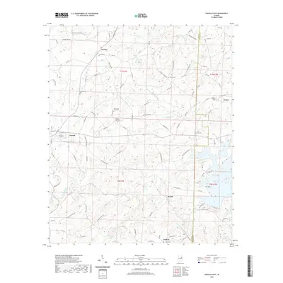
2020 Map of Lineville East
USGS Topo · Published 2020About this map
Lineville serves as the western anchor of this landscape, where the terrain begins its descent toward the eastern watercourses. The boundary between Clay Co and Randolph Co bisects the area, marked by a scattering of rural settlements including Barfield, Dingler, Berwick, and Cragford. The geography is defined by a dense network of creeks such as Mad Indian Cr and Prairie Cr, eventually feeding into the expansive R L Harris Reservoir in the southeast corner. For those tracing local heritage, the map is remarkably dense with family and community burial sites, from Dinglers Chapel Cem to the Old Pleasant Grove Cem. The transition from upland ridges to the reservoir shoreline near Flat Rock illustrates the modern hydrology of the region, while the grid of county roads and named routes like Youngs Mill Rd preserves the footprints of older homesteads.
Find a feature on this map
110 named features on this map. Tap any name to fly to it.
Don’t see what you’re looking for? This feature index may not catch every label — zoom into the map to look around manually.
Map Details
Editions of this 2020 Lineville East Map
This is the sole edition of this map. No revisions or reprints were ever made.
Other maps of this area

1891 · Ashland
USGS Topo · 1:125,000

1953 · Atlanta
USGS Topo · 1:250,000

1957 · Atlanta
USGS Topo · 1:250,000

1958 · Atlanta
USGS Topo · 1:250,000

1969 · Wadley North
USGS Topo · 1:24,000

1969 · Gibsonville
USGS Topo · 1:24,000

1969 · Mellow Valley
USGS Topo · 1:24,000
1969 · Cheaha Mountain
USGS Topo · 1:24,000
1969 · Lineville West
USGS Topo · 1:24,000
1970 · Delta
USGS Topo · 1:24,000