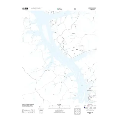
2013 Map of Linton
USGS Topo · Published 2013About this map
The expansive waters of Lake Barkley dominate this 2013 survey of the Kentucky-Tennessee border, where the flooded Cumberland River valley creates a complex network of bays and inlets. The settlement of Linton sits on the eastern shore near the mouth of Little Hurricane Cr, while the community of Tobaccoport is situated further south along the shoreline. This geography is defined by its numerous family burial grounds, including the Mt Vernon Cem, Wiggins Cem, and Champion Cem, which serve as vital markers for genealogical research in Trigg and Stewart counties. Extensive water features like Pryor Bay, Fords Bay, and Donaldson Cr illustrate the dramatic transformation of the landscape following the impoundment of the river. Inland, the terrain rises toward Fox Ridge and specialized landmarks like Williams Hollow, with the small crossroads of Model appearing in the southwestern portion of the sheet.
Find a feature on this map
99 named features on this map. Tap any name to fly to it.
Don’t see what you’re looking for? This feature index may not catch every label — zoom into the map to look around manually.
Map Details
Editions of this 2013 Linton Map
This is the sole edition of this map. No revisions or reprints were ever made.
Other maps of this area

1936 · Tharpe
USGS Topo · 1:24,000

1936 · Hamlin
USGS Topo · 1:24,000

1936 · Fenton
USGS Topo · 1:24,000

1936 · Golden Pond
USGS Topo · 1:48,000

1936 · Rushing
USGS Topo · 1:24,000

1950 · Rushing Creek
USGS Topo · 1:24,000
1950 · Fenton
USGS Topo · 1:24,000
1950 · Hamlin
USGS Topo · 1:24,000

1951 · Model
USGS Topo · 1:24,000

1951 · Johnson Hollow
USGS Topo · 1:24,000