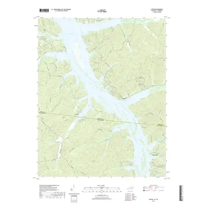
2019 Map of Linton
USGS Topo · Published 2019About this map
Lake Barkley dominates this landscape along the border of Trigg County, Kentucky, and Stewart County, Tennessee. The modern impoundment creates a complex shoreline of inlets and bays, such as Pryor Bay and Crockett Bay, while the surrounding terrain is defined by ridges like Fox Ridge and the S Bison Range. The area is notably dense with small family and community burial grounds, including Kingins Cem, Jimerson Cem, and Pleasant Hill Cem, which offer significant genealogical value for researchers of the borderlands. The settlement at Linton sits at the junction of Linton Rd and several creek drainages, while Tobaccoport is located further south near Pinner Spring Br. An unusual naming pattern for forest roads in the western portion utilizes figures from Western lore, with labels for Jesse James, Frank James, John Wayne, and Roy Rogers.
Find a feature on this map
119 named features on this map. Tap any name to fly to it.
Don’t see what you’re looking for? This feature index may not catch every label — zoom into the map to look around manually.
Map Details
Editions of this 2019 Linton Map
This is the sole edition of this map. No revisions or reprints were ever made.
Other maps of this area

1936 · Tharpe
USGS Topo · 1:24,000

1936 · Hamlin
USGS Topo · 1:24,000

1936 · Fenton
USGS Topo · 1:24,000

1936 · Golden Pond
USGS Topo · 1:48,000

1936 · Rushing
USGS Topo · 1:24,000

1950 · Rushing Creek
USGS Topo · 1:24,000
1950 · Fenton
USGS Topo · 1:24,000
1950 · Hamlin
USGS Topo · 1:24,000

1951 · Model
USGS Topo · 1:24,000

1951 · Johnson Hollow
USGS Topo · 1:24,000