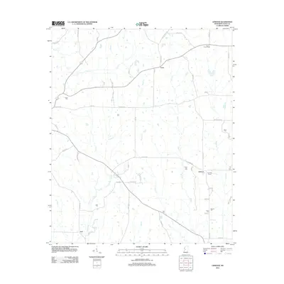
2012 Map of Linwood
USGS Topo · Published 2012About this map
The crossroads community of Linwood serves as a focal point in this portion of Mississippi, where the landscape is defined by its deep roots in agricultural and rural life. The terrain is crisscrossed by several winding waterways, including Cypress Cr and Burg Cr, which have historically shaped local settlement patterns and land use. For genealogists and local historians, the sheet is particularly valuable for its documentation of numerous small family and community burial grounds, such as Ellison Cem, Blaylock Cem, and Pickett Cem. These sites, often situated near minor rural roads like Odum Rd and Vaughan Rd, provide a physical link to the area's early residents. Landmarks such as the Midway Lookout Tower near Evans and the Linwood Airport underscore the mix of traditional forestry management and modern rural infrastructure present in the early 21st century.
Find a feature on this map
64 named features on this map. Tap any name to fly to it.
Don’t see what you’re looking for? This feature index may not catch every label — zoom into the map to look around manually.
Map Details
Editions of this 2012 Linwood Map
This is the sole edition of this map. No revisions or reprints were ever made.
Other maps of this area

1955 · Jackson
USGS Topo · 1:250,000

1961 · Jackson
USGS Topo · 1:250,000

1961 · Canton
USGS Topo · 1:62,500

1961 · Valley
USGS Topo · 1:62,500

1962 · Jackson
USGS Topo · 1:250,000

1962 · Flora
USGS Topo · 1:62,500
1964 · Zeiglerville
USGS Topo · 1:24,000
1964 · Ebenezer
USGS Topo · 1:24,000

1964 · Linwood
USGS Topo · 1:24,000

1964 · Vaughan
USGS Topo · 1:24,000