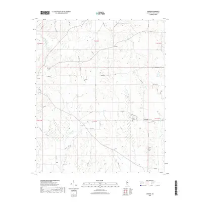
2018 Map of Linwood
USGS Topo · Published 2018About this map
Evans, Benton, and Linwood anchor this survey of the Yazoo County landscape, defined by a dense network of family-named cemeteries and rural roads that trace the undulating terrain. The area is heavily marked by its watercourses, including Piney Cr, Burg Cr, and Cypress Cr, which carve through the countryside. Cultural markers are prominent throughout the quadrangle, with numerous small burial sites such as Pickett Cem, Luce Cem, and Mount Zion Cem providing critical data points for genealogical research. The presence of Linwood Airport near the settlement of Linwood suggests a modern infrastructure overlaying an established agricultural and residential grid. Local thoroughfares like Vaughan Rd and Scotland Rd connect these disparate points, reflecting a rural community structure centered around small settlements and family landholdings.
Find a feature on this map
60 named features on this map. Tap any name to fly to it.
Don’t see what you’re looking for? This feature index may not catch every label — zoom into the map to look around manually.
Map Details
Editions of this 2018 Linwood Map
This is the sole edition of this map. No revisions or reprints were ever made.
Other maps of this area

1955 · Jackson
USGS Topo · 1:250,000

1961 · Jackson
USGS Topo · 1:250,000

1961 · Canton
USGS Topo · 1:62,500

1961 · Valley
USGS Topo · 1:62,500

1962 · Jackson
USGS Topo · 1:250,000

1962 · Flora
USGS Topo · 1:62,500
1964 · Zeiglerville
USGS Topo · 1:24,000
1964 · Ebenezer
USGS Topo · 1:24,000

1964 · Linwood
USGS Topo · 1:24,000

1964 · Vaughan
USGS Topo · 1:24,000