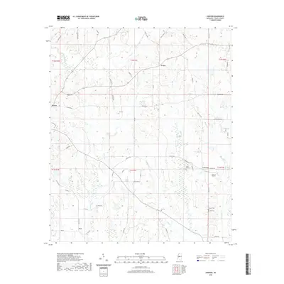
2020 Map of Linwood
USGS Topo · Published 2020About this map
Linwood Airport and a network of rural settlements define this section of Yazoo County during the early 21st century. The map reveals a high density of small family and community burial grounds, including Luce Cem, Pickett Cem, and Heard Cem, which are scattered among the ridges and drainages. The landscape is deeply etched by a complex hydrographic system where Piney Cr and Pickett Cr flow through the northern reaches, while Cypress Cr and King Cr dominate the south. This drainage pattern dictates the winding paths of local roads like Wildwood Rd and Vaughan Rd. The proximity of Linwood and Benton highlights the area's ongoing role as a rural hub, preserved here just as modern infrastructure and older land divisions intersect.
Find a feature on this map
64 named features on this map. Tap any name to fly to it.
Don’t see what you’re looking for? This feature index may not catch every label — zoom into the map to look around manually.
Map Details
Editions of this 2020 Linwood Map
This is the sole edition of this map. No revisions or reprints were ever made.
Other maps of this area

1955 · Jackson
USGS Topo · 1:250,000

1961 · Jackson
USGS Topo · 1:250,000

1961 · Canton
USGS Topo · 1:62,500

1961 · Valley
USGS Topo · 1:62,500

1962 · Jackson
USGS Topo · 1:250,000

1962 · Flora
USGS Topo · 1:62,500
1964 · Zeiglerville
USGS Topo · 1:24,000
1964 · Ebenezer
USGS Topo · 1:24,000

1964 · Linwood
USGS Topo · 1:24,000

1964 · Vaughan
USGS Topo · 1:24,000