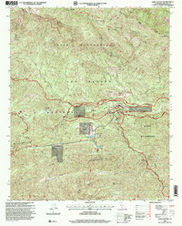
1995 Map of Lion Canyon
USGS Topo · Published 2000About this map
Rose Valley serves as a central corridor for recreation and limited settlement within the expansive Los Padres National Forest. The landscape is defined by the winding course of Sespe Creek and the Sespe River, which are flanked by the high elevations of Pine Mountain to the north and Nordhoff Ridge to the south. Local human activity is concentrated around Rose Valley Ranch, the Ojai Valley Gun Club, and the Rancho Grande complex, which includes a dedicated Landing Strip. The presence of several backcountry locations such as Thacher Cabin and Pine Mountain Lodge alongside numerous springs indicates a long history of trail-use and forest management. Significant landmarks like Rose Valley Falls and the jagged Piedra Blanca Creek drainage illustrate the transition from valley floors to the high-altitude peaks of Chief Peak and Thorn Point.
Find a feature on this map
65 named features on this map. Tap any name to fly to it.
Don’t see what you’re looking for? This feature index may not catch every label — zoom into the map to look around manually.
Map Details
Editions of this 1995 Lion Canyon Map
This is the sole edition of this map. No revisions or reprints were ever made.
Other maps of this area

1903 · Santa Paula
USGS Topo · 1:62,500

1903 · Mt. Pinos
USGS Topo · 1:125,000

1904 · Ventura
USGS Topo · 1:62,500

1941 · Ventura
USGS Topo · 1:62,500

1942 · Santa Paula
USGS Topo · 1:62,500

1942 · Wheeler Springs
USGS Topo · 1:24,000

1943 · Topatopa Mountains
USGS Topo · 1:24,000

1943 · San Guillermo
USGS Topo · 1:24,000

1943 · Lockwood Valley
USGS Topo · 1:24,000

1943 · Lion Canyon
USGS Topo · 1:24,000