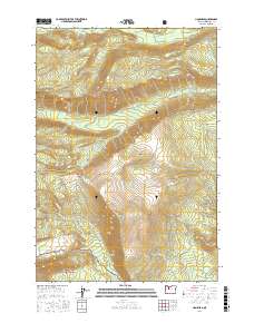
2017 Map of Lionshead
USGS Topo · Published 2017About this map
Deschutes National Forest encompasses this section of Jefferson County, characterized by a complex drainage system feeding the Whitewater River and several major creeks. The topography is defined by prominent high points such as Lionshead, Camp Creek Butte, and the summit of Bald Peter. Hydrological management is evidenced by the Camp Creek Reservoir in the central portion of the quadrangle, which captures flow from Camp Creek. The map details a network of forest roads and land divisions, including numbered blocks like PB 40 and PB 41, while providing clear coordinates for navigating the varied elevations between Biddle Pass and the lowlands of Peters Pasture. Numerous waterways including Shitike Creek, Milk Creek, and Jefferson Creek carve through the terrain, illustrating the natural watershed patterns of the Oregon Cascades in the early 21st century.
Find a feature on this map
33 named features on this map. Tap any name to fly to it.
Don’t see what you’re looking for? This feature index may not catch every label — zoom into the map to look around manually.
Map Details
Editions of this 2017 Lionshead Map
This is the sole edition of this map. No revisions or reprints were ever made.
Other maps of this area

1927 · Mt. Jefferson
USGS Topo · 1:125,000

1930 · Mt. Jefferson
USGS Topo · 1:125,000

1955 · Bend
USGS Topo · 1:250,000

1957 · Bend
USGS Topo · 1:250,000

1958 · Bend
USGS Topo · 1:250,000

1961 · Whitewater River
USGS Topo · 1:62,500

1961 · Fort Butte
USGS Topo · 1:62,500
1961 · Mt. Jefferson
USGS Topo · 1:62,500
1961 · Breitenbush Hot Springs
USGS Topo · 1:62,500
1983 · Madras
USGS Topo · 1:100,000