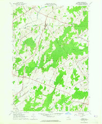
1963 Map of Lisbon
USGS Topo · Published 1965About this map
The town of Lisbon serves as the central hub of this St. Lawrence County landscape during the early 1960s. The village is anchored by the Lisbon Central Sch and the Lisbon Cem, while a network of rural roads such as Dezell Road and Morley Road connects outlying hamlets. Evidence of the region's changing transportation is found in the Abandoned railroad line passing through the heart of the township. Southward, the settlement of Flackville is marked by the Flackville Cem and the Covenanter Ch. The terrain is defined by low-lying wetlands and wandering watercourses like Sucker Brook and Brandy Creek, interspersed with numerous sand and gravel operations. Local family names are preserved at rural crossroads including Gregory Corners, Woodbridge Corners, and North Corners, providing a detailed look at the agricultural and residential patterns of mid-century upstate New York.
Find a feature on this map
51 named features on this map. Tap any name to fly to it.
Don’t see what you’re looking for? This feature index may not catch every label — zoom into the map to look around manually.
Map Details
Editions of this 1963 Lisbon Map
2 editions found
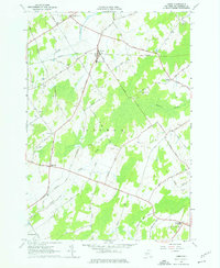
Other maps of this area

1904 · Lisbon
USGS Topo · 1:48,000

1904 · Ogdensburg
USGS Topo · 1:62,500

1905 · Waddington
USGS Topo · 1:62,500

1905 · Ogdensburg
USGS Topo · 1:62,500

1906 · Red Mills
USGS Topo · 1:62,500

1910 · Canton
USGS Topo · 1:62,500

1911 · Canton
USGS Topo · 1:62,500

1942 · Waddington
USGS Topo · 1:24,000

1943 · Ogdensburg East
USGS Topo · 1:31,680

1943 · Rensselaer Falls
USGS Topo · 1:31,680