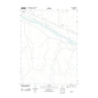
2011 Map of Lisco
USGS Topo · Published 2011About this map
Lisco serves as a focal point along the northern banks of the North Platte River in Garden County. This landscape is defined by its extensive water management infrastructure, where the Lisco Canal and the North River Canal parallel the braided river system to support regional agriculture. The presence of the Balka Group Dam and the confluence of Coldwater Creek and Rush Creek with the main river channel illustrate the complex hydrology of the High Plains. The small community is anchored by the Lisco Post Office, while a network of rural routes like Road 54 and Road 151 provides access through the expansive river valley and surrounding tablelands.
Find a feature on this map
14 named features on this map. Tap any name to fly to it.
Don’t see what you’re looking for? This feature index may not catch every label — zoom into the map to look around manually.
Map Details
Editions of this 2011 Lisco Map
This is the sole edition of this map. No revisions or reprints were ever made.
Other maps of this area

1896 · Browns Creek
USGS Topo · 1:125,000

1899 · Browns Creek
USGS Topo · 1:125,000

1899 · Sidney
USGS Topo · 1:125,000

1900 · Chappell
USGS Topo · 1:125,000

1950 · Crescent Lake
USGS Topo · 1:62,500

1954 · Scottsbluff
USGS Topo · 1:250,000

1958 · Scottsbluff
USGS Topo · 1:250,000

1971 · Oshkosh SW
USGS Topo · 1:24,000

1971 · Coumbe Bluff
USGS Topo · 1:24,000

1971 · Tar Valley SW
USGS Topo · 1:24,000