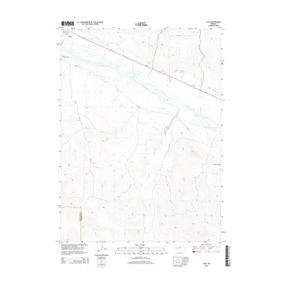
2014 Map of Lisco
USGS Topo · Published 2014About this map
The North Platte River carves a wide, braided path through this Nebraska landscape, defining the character of the High Plains settlement at Lisco. This 2014 survey illustrates a sophisticated network of water management essential to the region's agricultural economy, prominently featuring the Lisco Canal, the N River Canal, and the Balka Group Reservoir. These man-made features run parallel to natural drainages like Coldwater Cr and Rush Cr, showing how irrigation has reshaped the valley. The small community of Lisco serves as a local hub, with its street grid including 1st ST and 2nd ST situated near the Lisco Memorial Cem. The map also captures the transition from the river valley to the more varied terrain of Wolf Canyon and the county line shared by Cheyenne Co and Garden Co, providing a clear record of land use and civil boundaries in the early 21st century.
Find a feature on this map
20 named features on this map. Tap any name to fly to it.
Don’t see what you’re looking for? This feature index may not catch every label — zoom into the map to look around manually.
Map Details
Editions of this 2014 Lisco Map
This is the sole edition of this map. No revisions or reprints were ever made.
Other maps of this area

1896 · Browns Creek
USGS Topo · 1:125,000

1899 · Browns Creek
USGS Topo · 1:125,000

1899 · Sidney
USGS Topo · 1:125,000

1900 · Chappell
USGS Topo · 1:125,000

1950 · Crescent Lake
USGS Topo · 1:62,500

1954 · Scottsbluff
USGS Topo · 1:250,000

1958 · Scottsbluff
USGS Topo · 1:250,000

1971 · Oshkosh SW
USGS Topo · 1:24,000

1971 · Coumbe Bluff
USGS Topo · 1:24,000

1971 · Tar Valley SW
USGS Topo · 1:24,000