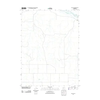
2011 Map of Lisco NW
USGS Topo · Published 2011About this map
The North Platte River winds through the northeast corner of this Nebraska landscape, where the Belmont Canal also follows the waterway's general path. This high-plains terrain is defined by a sparse but rigid grid of section roads, including Road 58 and Road 54, which serve the expansive agricultural and ranching tracts of Cheyenne County. On the high ground overlooking the river valley, the Lisco Memorial Cemetery stands as a significant local landmark for genealogists and family historians. The map documents a classic Western interior landscape where water management, via the canal and river system, remains the primary driver of settlement and land use. The network of numbered routes like Road 143 and Road 88 provides a clear view of the rural infrastructure at the beginning of the 2010s.
Find a feature on this map
14 named features on this map. Tap any name to fly to it.
Don’t see what you’re looking for? This feature index may not catch every label — zoom into the map to look around manually.
Map Details
Editions of this 2011 Lisco NW Map
This is the sole edition of this map. No revisions or reprints were ever made.
Other maps of this area

1896 · Browns Creek
USGS Topo · 1:125,000

1899 · Browns Creek
USGS Topo · 1:125,000

1899 · Sidney
USGS Topo · 1:125,000

1954 · Scottsbluff
USGS Topo · 1:250,000

1958 · Scottsbluff
USGS Topo · 1:250,000

1965 · Broadwater
USGS Topo · 1:24,000

1971 · Tar Valley SW
USGS Topo · 1:24,000
1971 · Buske Ranch
USGS Topo · 1:24,000

1972 · Lisco NW
USGS Topo · 1:24,000
1972 · Fairchild Ranch
USGS Topo · 1:24,000