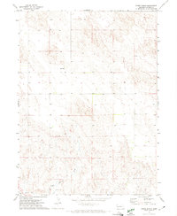
1971 Map of Buske Ranch
USGS Topo · Published 1974About this map
Buske Ranch sits within a sparsely settled portion of Garden County, where the topography of the Nebraska Sandhills dictates the local water management and ranching operations. The southern portion of the landscape is defined by the Lisco Canal, an essential irrigation feature for the Platte River valley just to the south. The intermittent flow of Coldwater Creek and several isolated Springs and a lone Spring provide the primary water sources for livestock in this arid environment. This 1971 survey, based on aerial photography from two years prior, captures the rural infrastructure of the High Plains before modern industrial ranching methods further transformed the open range. The map reveals a land characterized by rolling sand dunes and natural drainage patterns where human intervention is limited to a handful of vital water-conveyance systems and private ranch headquarters.
Find a feature on this map
5 named features on this map. Tap any name to fly to it.
Don’t see what you’re looking for? This feature index may not catch every label — zoom into the map to look around manually.
Map Details
Editions of this 1971 Buske Ranch Map
This is the sole edition of this map. No revisions or reprints were ever made.
Other maps of this area

1896 · Browns Creek
USGS Topo · 1:125,000

1899 · Browns Creek
USGS Topo · 1:125,000

1899 · Sidney
USGS Topo · 1:125,000

1900 · Chappell
USGS Topo · 1:125,000

1950 · Crescent Lake
USGS Topo · 1:62,500

1954 · Scottsbluff
USGS Topo · 1:250,000

1958 · Scottsbluff
USGS Topo · 1:250,000

1971 · Richardson Lake
USGS Topo · 1:24,000

1971 · Coumbe Bluff
USGS Topo · 1:24,000

1971 · Tar Valley SW
USGS Topo · 1:24,000