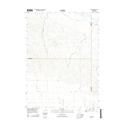
2014 Map of Lisco NW
USGS Topo · Published 2014About this map
The North Platte River flows through the northeastern corner of this Nebraska landscape, where the high plains meet the river valley. This 2014 survey captures a rural area defined by its tri-county intersection, where Morrill, Garden, and Cheyenne counties converge. The local infrastructure is oriented around the agricultural water needs of the region, specifically shown by the Belmont Canal which skirts the western hills to provide irrigation from the river. While the terrain is characterized by complex contouring and numerous intermittent drainages, the human footprint is marked by a strict section-line road grid, including Road 145 and Road 58. Genealogists may find interest in the Lisco Memorial Cem, located near the northern border, serving as a primary landmark for the sparse settlements in this corner of the state.
Find a feature on this map
17 named features on this map. Tap any name to fly to it.
Don’t see what you’re looking for? This feature index may not catch every label — zoom into the map to look around manually.
Map Details
Editions of this 2014 Lisco NW Map
This is the sole edition of this map. No revisions or reprints were ever made.
Other maps of this area

1896 · Browns Creek
USGS Topo · 1:125,000

1899 · Browns Creek
USGS Topo · 1:125,000

1899 · Sidney
USGS Topo · 1:125,000

1954 · Scottsbluff
USGS Topo · 1:250,000

1958 · Scottsbluff
USGS Topo · 1:250,000

1965 · Broadwater
USGS Topo · 1:24,000

1971 · Tar Valley SW
USGS Topo · 1:24,000
1971 · Buske Ranch
USGS Topo · 1:24,000

1972 · Lisco NW
USGS Topo · 1:24,000
1972 · Fairchild Ranch
USGS Topo · 1:24,000