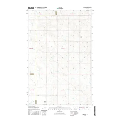
2017 Map of Lisk Creek
USGS Topo · Published 2017About this map
The Redwater River winds through this sparsely settled corner of Eastern Montana, defining a landscape carved by a complex network of coulees and seasonal creeks. The confluence of several drainages, including the N Fork Lisk Cr and S Fork Lisk Cr, creates a rugged topography that dictates the placement of the few maintained county roads. This area sits at a significant political junction where the borders of McCone, Dawson, and Richland counties meet, illustrating the expansive nature of rural land management in the region.
Find a feature on this map
22 named features on this map. Tap any name to fly to it.
Don’t see what you’re looking for? This feature index may not catch every label — zoom into the map to look around manually.
Map Details
Editions of this 2017 Lisk Creek Map
This is the sole edition of this map. No revisions or reprints were ever made.
Other maps of this area

1954 · Glendive
USGS Topo · 1:250,000

1957 · Glendive
USGS Topo · 1:250,000

1958 · Glendive
USGS Topo · 1:250,000
1983 · Duplisse Creek North
USGS Topo · 1:24,000
1983 · Sullivan Coulee
USGS Topo · 1:24,000
1983 · Duplisse Creek South
USGS Topo · 1:24,000
1983 · Richey
USGS Topo · 1:24,000

1983 · Buffalo Creek NE
USGS Topo · 1:24,000
1983 · Kraut Coulee
USGS Topo · 1:24,000

1983 · Richey NW
USGS Topo · 1:24,000