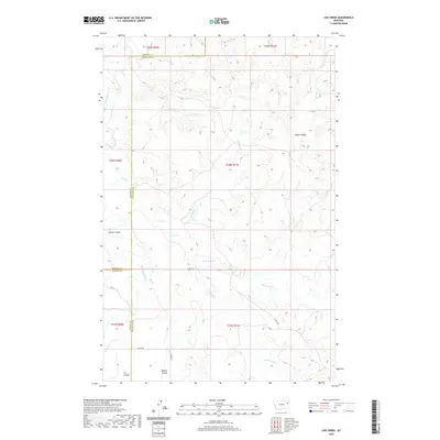
2020 Map of Lisk Creek
USGS Topo · Published 2020About this map
The Redwater River defines the western edge of this landscape, where the prairie of eastern Montana is carved by a complex network of coulees and creeks. This 2020 map documents the remote drainage basin where Lisk Cr branches into its northern and southern forks. Named geographic features like Bickett Coulee and Kraut Coulee suggest a history of early ranching and homesteading, marking the depressions that provide vital shelter and water sources in this arid region.
Find a feature on this map
16 named features on this map. Tap any name to fly to it.
Don’t see what you’re looking for? This feature index may not catch every label — zoom into the map to look around manually.
Map Details
Editions of this 2020 Lisk Creek Map
This is the sole edition of this map. No revisions or reprints were ever made.
Other maps of this area

1954 · Glendive
USGS Topo · 1:250,000

1957 · Glendive
USGS Topo · 1:250,000

1958 · Glendive
USGS Topo · 1:250,000
1983 · Duplisse Creek North
USGS Topo · 1:24,000
1983 · Sullivan Coulee
USGS Topo · 1:24,000
1983 · Duplisse Creek South
USGS Topo · 1:24,000
1983 · Richey
USGS Topo · 1:24,000

1983 · Buffalo Creek NE
USGS Topo · 1:24,000
1983 · Kraut Coulee
USGS Topo · 1:24,000

1983 · Richey NW
USGS Topo · 1:24,000