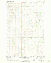
1970 Map of Litchville SE
USGS Topo · Published 1973About this map
Litchville and its surrounding plains are depicted here during a 1970 field check, revealing a landscape defined by glacial activity and early agricultural township patterns. The terrain is divided into localized districts such as Black Loam, North Land, and Fort Ransom, reflecting the soil-focused priorities of the regional farming community. Significant for genealogists and local historians, the sheet identifies rural landmarks including the North LaMoure Ch and Sulli Cem, which served the scattered homesteads of the era. The meandering course of Bear Creek cuts through the eastern portion of the map, illustrating the natural drainage system of the North Dakota prairie before the modern expansion of drainage works. A prominent Radio Tower stands as a vertical marker on the horizontal expanse, while the county line between LaMoure Co and Ransom Co provides a clear administrative boundary for property researchers.
Find a feature on this map
9 named features on this map. Tap any name to fly to it.
Don’t see what you’re looking for? This feature index may not catch every label — zoom into the map to look around manually.
Map Details
Editions of this 1970 Litchville SE Map
This is the sole edition of this map. No revisions or reprints were ever made.
Other maps of this area

1895 · Lamoure
USGS Topo · 1:125,000

1897 · Tower
USGS Topo · 1:125,000

1897 · Eckelson
USGS Topo · 1:125,000

1918 · La Moure
USGS Topo · 1:125,000

1953 · Jamestown
USGS Topo · 1:250,000

1953 · Fargo
USGS Topo · 1:250,000

1956 · Fargo
USGS Topo · 1:250,000

1956 · Jamestown
USGS Topo · 1:250,000
1962 · Englevale
USGS Topo · 1:24,000

1967 · Ft. Ransom
USGS Topo · 1:24,000
Featured Places
- Litchville Township, ND
- Black Loam Township, ND
- Fort Ransom Township, ND
- Northland Township, ND
- Ransom County, ND