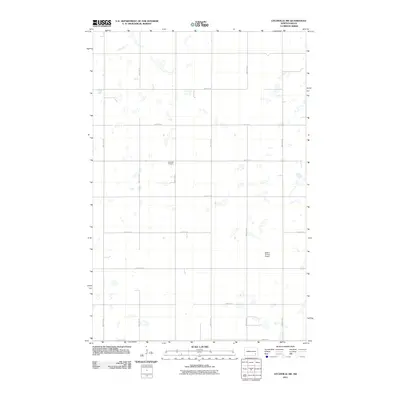
2011 Map of Litchville SW
USGS Topo · Published 2011About this map
Griswold Cemetery sits at the heart of this North Dakota landscape, a quiet marker of the early 20th-century agrarian settlement in LaMoure County. The map reveals a highly structured section-line road network, including 104th Ave SE and 107th Ave SE, which define the rigid grid of the American prairie. This area is characterized by numerous small, scattered wetlands and depressions typical of the regional topography, where the natural hydrology persists despite the formal overlay of township and range lines. Transportation through the territory is anchored by County Rd 35, while the presence of the Nelson Private Airport reflects the continued importance of private aviation for modern agricultural operations and rural connectivity.
Find a feature on this map
16 named features on this map. Tap any name to fly to it.
Don’t see what you’re looking for? This feature index may not catch every label — zoom into the map to look around manually.
Map Details
Editions of this 2011 Litchville SW Map
This is the sole edition of this map. No revisions or reprints were ever made.
Other maps of this area

1894 · La Moure
USGS Topo · 1:62,500

1895 · Lamoure
USGS Topo · 1:125,000

1897 · Eckelson
USGS Topo · 1:125,000

1918 · La Moure
USGS Topo · 1:125,000

1952 · Grand Rapids
USGS Topo · 1:24,000

1953 · Jamestown
USGS Topo · 1:250,000

1956 · Jamestown
USGS Topo · 1:250,000

1970 · Litchville
USGS Topo · 1:24,000
1970 · Hastings
USGS Topo · 1:24,000
1970 · Verona NW
USGS Topo · 1:24,000
Featured Places
- Prairie Township, ND
- Black Loam Township, ND
- Gladstone Township, ND
- Litchville Township, ND
- LaMoure County, ND