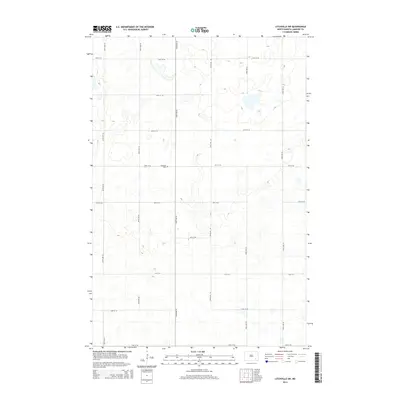
2014 Map of Litchville SW
USGS Topo · Published 2014About this map
Griswold Cem, located near the intersection of 58th St SE and 106th Ave SE, serves as a primary historical landmark in this agricultural landscape of LaMoure County. The terrain is defined by the high density of prairie potholes and small wetlands that characterize this portion of the northern plains. A rigid section-line road grid, including north-south corridors like 104th Ave SE and east-west routes such as 60th St SE, organizes the territory into a patchwork of productive fields. This spatial arrangement reflects the enduring legacy of the Public Land Survey System, which dictated the settlement patterns and transportation networks still visible in the early 21st century.
Find a feature on this map
16 named features on this map. Tap any name to fly to it.
Don’t see what you’re looking for? This feature index may not catch every label — zoom into the map to look around manually.
Map Details
Editions of this 2014 Litchville SW Map
This is the sole edition of this map. No revisions or reprints were ever made.
Other maps of this area

1894 · La Moure
USGS Topo · 1:62,500

1895 · Lamoure
USGS Topo · 1:125,000

1897 · Eckelson
USGS Topo · 1:125,000

1918 · La Moure
USGS Topo · 1:125,000

1952 · Grand Rapids
USGS Topo · 1:24,000

1953 · Jamestown
USGS Topo · 1:250,000

1956 · Jamestown
USGS Topo · 1:250,000

1970 · Litchville
USGS Topo · 1:24,000
1970 · Hastings
USGS Topo · 1:24,000
1970 · Verona NW
USGS Topo · 1:24,000
Featured Places
- Prairie Township, ND
- Black Loam Township, ND
- Gladstone Township, ND
- Litchville Township, ND
- LaMoure County, ND