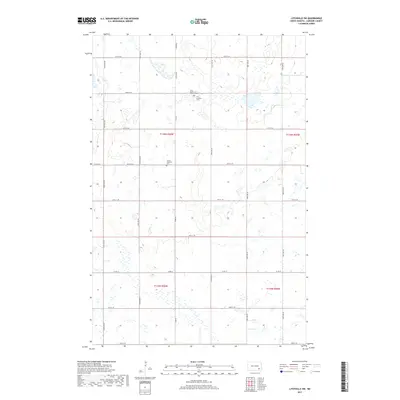
2017 Map of Litchville SW
USGS Topo · Published 2017About this map
The agrarian landscape of LaMoure County is defined by a rigorous section-line grid, where scattered prairie wetlands dot the terrain between cultivated fields. This 2017 survey reveals the enduring presence of early community life through its rural cemeteries, often the primary landmarks in an otherwise open horizon. Near the junction of Co Rd 60 and 56th St SE, the First Reformed Church Cem and First Lutheran Cem stand in close proximity, marking the spiritual and genealogical center of the township. Further south along the section lines, Trinity Lutheran Cem serves as another focal point for local history. The map's network of gravel and paved routes, such as Co Rd 35 and 104th Ave SE, illustrates the persistent geometry of North Dakota's township system, providing a clear reference for those tracing family plots or early land divisions in this part of the state.
Find a feature on this map
23 named features on this map. Tap any name to fly to it.
Don’t see what you’re looking for? This feature index may not catch every label — zoom into the map to look around manually.
Map Details
Editions of this 2017 Litchville SW Map
This is the sole edition of this map. No revisions or reprints were ever made.
Other maps of this area

1894 · La Moure
USGS Topo · 1:62,500

1895 · Lamoure
USGS Topo · 1:125,000

1897 · Eckelson
USGS Topo · 1:125,000

1918 · La Moure
USGS Topo · 1:125,000

1952 · Grand Rapids
USGS Topo · 1:24,000

1953 · Jamestown
USGS Topo · 1:250,000

1956 · Jamestown
USGS Topo · 1:250,000

1970 · Litchville
USGS Topo · 1:24,000
1970 · Hastings
USGS Topo · 1:24,000
1970 · Verona NW
USGS Topo · 1:24,000
Featured Places
- Prairie Township, ND
- Black Loam Township, ND
- Gladstone Township, ND
- Litchville Township, ND
- LaMoure County, ND