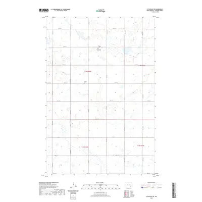
2020 Map of Litchville SW
USGS Topo · Published 2020About this map
Small rural cemeteries and section-line roads define the agricultural landscape of this corner of LaMoure County. Located north of the intersection of Co Rd 60 and 56th St SE, the First Lutheran Cem and First Reformed Church Cem stand as markers of the Norwegian and German heritage that shaped the region’s early settlement. Further south, the Trinity Lutheran Cem is situated along 58th St SE, emphasizing the religious foundations of these small farming communities. The terrain is characterized by the complex glacial potholes and wetlands typical of the Missouri Coteau, where seasonal water bodies are scattered across the township grid. The road network, including arterial routes like Co Rd 35, remains the primary structural element of this quiet prairie landscape, providing a clear view of the rural land divisions and property boundaries established over a century ago.
Find a feature on this map
22 named features on this map. Tap any name to fly to it.
Don’t see what you’re looking for? This feature index may not catch every label — zoom into the map to look around manually.
Map Details
Editions of this 2020 Litchville SW Map
This is the sole edition of this map. No revisions or reprints were ever made.
Other maps of this area

1894 · La Moure
USGS Topo · 1:62,500

1895 · Lamoure
USGS Topo · 1:125,000

1897 · Eckelson
USGS Topo · 1:125,000

1918 · La Moure
USGS Topo · 1:125,000

1952 · Grand Rapids
USGS Topo · 1:24,000

1953 · Jamestown
USGS Topo · 1:250,000

1956 · Jamestown
USGS Topo · 1:250,000

1970 · Litchville
USGS Topo · 1:24,000
1970 · Hastings
USGS Topo · 1:24,000
1970 · Verona NW
USGS Topo · 1:24,000
Featured Places
- Prairie Township, ND
- Black Loam Township, ND
- Gladstone Township, ND
- Litchville Township, ND
- LaMoure County, ND