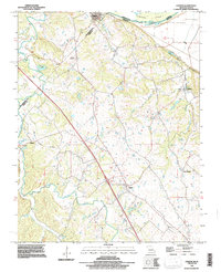
1993 Map of Lithium
USGS Topo · Published 1996About this map
The Old Kaskaskia River and its accompanying levee system define the northern border of this Missouri-Illinois landscape, where the shifting riverbed historically shaped the boundary between Randolph and Perry counties. South of the floodplain, the terrain rises into the rolling hills of Perry County, punctuated by unique geological features like the Ball Mill Resurgence near Blue Spring. The settlement of Lithium sits in the northeast, while the southern reaches are dominated by the winding path of Saline Creek and its tributaries, including the South Fork Saline Creek.
Find a feature on this map
25 named features on this map. Tap any name to fly to it.
Don’t see what you’re looking for? This feature index may not catch every label — zoom into the map to look around manually.
Map Details
Editions of this 1993 Lithium Map
This is the sole edition of this map. No revisions or reprints were ever made.
Other maps of this area

1907 · Weingarten
USGS Topo · 1:62,500

1909 · Weingarten
USGS Topo · 1:62,500

1910 · Higdon
USGS Topo · 1:62,500

1915 · Chester
USGS Topo · 1:62,500

1923 · Perryville
USGS Topo · 1:62,500

1924 · Perryville
USGS Topo · 1:62,500

1947 · Chester
USGS Topo · 1:62,500

1949 · Paducah
USGS Topo · 1:250,000

1949 · Rolla
USGS Topo · 1:250,000

1950 · Paducah
USGS Topo · 1:250,000