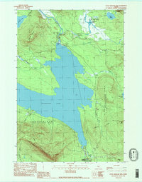
1989 Map of Little Bigelow Mtn
USGS Topo · Published 1989About this map
Little Bigelow Mountain and the surrounding wilderness of Somerset and Franklin Counties dominate this late-1980s topographic study. The landscape is defined by the massive footprint of Flagstaff Lake, created by the Flagstaff Dam on the Dead River. This artificial reservoir submerged several earlier settlements, leaving a quiet shoreline now used for recreation, as evidenced by a Picnic Area and several Campsite locations.
Find a feature on this map
33 named features on this map. Tap any name to fly to it.
Don’t see what you’re looking for? This feature index may not catch every label — zoom into the map to look around manually.
Map Details
Editions of this 1989 Little Bigelow Mtn Map
2 editions found
Other maps of this area

1925 · Pierce Pond
USGS Topo · 1:48,000

1927 · Pierce Pond
USGS Topo · 1:62,500

1928 · Spencer
USGS Topo · 1:48,000

1928 · Dead River
USGS Topo · 1:62,500

1928 · Stratton
USGS Topo · 1:48,000

1931 · Dead River
USGS Topo · 1:48,000

1932 · Stratton
USGS Topo · 1:62,500

1932 · Spencer
USGS Topo · 1:62,500

1944 · Dead River
USGS Topo · 1:62,500

1944 · Pierce Pond
USGS Topo · 1:62,500
Featured Places
- Carrabassett Valley, ME
- Highland Plantation, ME
- Dead River Township, ME
- Spring Lake Township, ME
- Carrying Place Town Township, ME