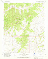
1967 Map of Little Black Spot Mtn
USGS Topo · Published 1969About this map
Little Black Spot Mtn stands as a central landmark in this high-desert landscape of Navajo County, reflecting the complex land management of the late 1960s. The map illustrates a transitional geography where the White Valley meets the northern reaches of First Mesa. Large portions of the terrain are designated within the Navajo Hopi Joint Use Area and the Hopi Indian Reservation, capturing a specific moment in the administrative history of these tribal lands. Small settlements and points of interest such as Chilchinbeto, Hostiin Akahibito, and Tolah Nasein are scattered across the quadrangle, connected by unimproved roads. Water sources are critical features in this arid environment, marked by numerous named points including Ponderosa Pine Spring, Pigeon Spring, and Rough Rock Well. The drainage patterns of Wepo Wash further define the topography of this isolated region.
Find a feature on this map
20 named features on this map. Tap any name to fly to it.
Don’t see what you’re looking for? This feature index may not catch every label — zoom into the map to look around manually.
Map Details
Editions of this 1967 Little Black Spot Mtn Map
This is the sole edition of this map. No revisions or reprints were ever made.
Other maps of this area

1883 · Marsh Pass
USGS Topo · 1:250,000

1883 · Tusayan
USGS Topo · 1:250,000

1886 · Tusayan
USGS Topo · 1:250,000

1892 · Marsh Pass
USGS Topo · 1:250,000

1947 · Flagstaff
USGS Topo · 1:250,000

1954 · Flagstaff
USGS Topo · 1:250,000

1956 · Marble Canyon
USGS Topo · 1:250,000

1958 · Flagstaff
USGS Topo · 1:250,000

1959 · Marble Canyon
USGS Topo · 1:250,000

1960 · Flagstaff
USGS Topo · 1:250,000