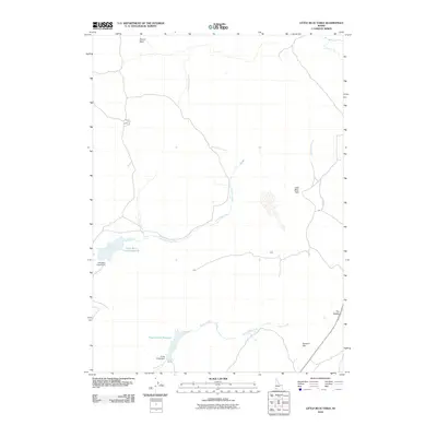
2010 Map of Little Blue Table
USGS Topo · Published 2010About this map
Little Blue Table dominates the central portion of this Owyhee County high-desert landscape, where land-use patterns are dictated by the presence of seasonal water. The geography is defined by a series of drainages and man-made impoundments essential for ranching and land management in this arid environment. Key water-control points include the Little Blue Creek Reservoir, held by the Little Blue Creek Dam, and the Payne Creek Reservoir further south near the Paine Creek Dam. These structures manage the flow of Little Blue Creek and Payne Creek as they traverse the plateau. The terrain is marked by distinct landforms such as Buncel Basin in the north and the broad expanse of Summit Flat to the southeast. These features, along with Rattlesnake Creek and The Saddle, illustrate the topographical character of Idaho's southwestern corner in the early 21st century.
Find a feature on this map
12 named features on this map. Tap any name to fly to it.
Don’t see what you’re looking for? This feature index may not catch every label — zoom into the map to look around manually.
Map Details
Editions of this 2010 Little Blue Table Map
This is the sole edition of this map. No revisions or reprints were ever made.
Other maps of this area

1955 · Jordan Valley
USGS Topo · 1:250,000

1955 · Twin Falls
USGS Topo · 1:250,000

1957 · Jordan Valley
USGS Topo · 1:250,000

1958 · Twin Falls
USGS Topo · 1:250,000

1958 · Jordan Valley
USGS Topo · 1:250,000
1971 · Flying H Ranch
USGS Topo · 1:24,000
1971 · Riddle
USGS Topo · 1:24,000

1972 · Wickahoney Point
USGS Topo · 1:24,000

1972 · Little Blue Table
USGS Topo · 1:24,000

1972 · Turner Table
USGS Topo · 1:24,000