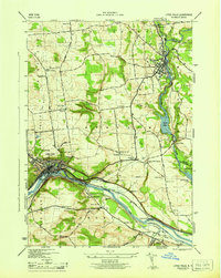
1946 Map of Little Falls
USGS Topo · Published 1946About this map
The Mohawk River corridor dominates this mid-century topographic record, where the industrial and transport infrastructure of Little Falls meets the agricultural uplands of Salisbury and Manheim. The map documents a critical nexus of New York transit, showing the Barge Canal running parallel to the New York Central railroad through the narrow river gap. Outside the main river valley, the landscape is dotted with rural identifiers essential for family history, including numerous schoolhouses from School No 1 to School No 9 and distinctive landmarks like the Yellow Ch and the Airway Beacon. Settlement patterns follow the water, from the concentrated center of Dolgeville on East Canada Creek down to the smaller hamlets of Ingham Mills and the riverside Fink Basin. This survey preserves the exact placement of several burial grounds, including the St Marys Cem and the Fink-Van Valkenburg Cem, near the site of Indian Castle.
Find a feature on this map
52 named features on this map. Tap any name to fly to it.
Don’t see what you’re looking for? This feature index may not catch every label — zoom into the map to look around manually.
Map Details
Editions of this 1946 Little Falls Map
This is the sole edition of this map. No revisions or reprints were ever made.
Other maps of this area

1898 · Canajoharie
USGS Topo · 1:62,500

1900 · Little Falls
USGS Topo · 1:62,500

1900 · Canajoharie
USGS Topo · 1:62,500

1901 · Lassellsville
USGS Topo · 1:62,500

1902 · Canajoharie
USGS Topo · 1:62,500

1903 · Richfield Springs
USGS Topo · 1:62,500

1903 · Lassellsville
USGS Topo · 1:62,500

1903 · Little Falls
USGS Topo · 1:62,500

1939 · Little Falls
USGS Topo · 1:62,500

1943 · Jordanville
USGS Topo · 1:24,000