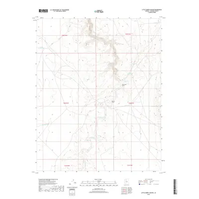
2018 Map of Little Harpo Canyon
USGS Topo · Published 2018About this map
Cataract Canyon and its tributary, Little Harpo Canyon, carve through this Coconino County landscape, revealing the intricate drainage patterns typical of northern Arizona's high plateaus. The topography is defined by the winding course of Cataract Creek, which transitions through the terrain alongside several man-made water catchments crucial for ranching and livestock in this arid environment. Named features like New Harpo Tank and Little Harpo Tank suggest a history of local land management, where every depression and pond served a vital purpose. The map also captures several smaller livestock tanks such as Jericho Tank and Shilo Tank, scattered across the township and range lines. These features illustrate the essential infrastructure required for survival and industry in a region where natural water sources like Red Dike Pond are few and far between.
Find a feature on this map
18 named features on this map. Tap any name to fly to it.
Don’t see what you’re looking for? This feature index may not catch every label — zoom into the map to look around manually.
Map Details
Editions of this 2018 Little Harpo Canyon Map
This is the sole edition of this map. No revisions or reprints were ever made.
Other maps of this area

1886 · Chino
USGS Topo · 1:250,000

1891 · Chino
USGS Topo · 1:250,000

1948 · Williams
USGS Topo · 1:250,000

1954 · Williams
USGS Topo · 1:250,000

1956 · Williams
USGS Topo · 1:250,000

1960 · Williams
USGS Topo · 1:250,000

1961 · Williams
USGS Topo · 1:250,000
1979 · Box K Ranch
USGS Topo · 1:24,000

1979 · Little Harpo Canyon
USGS Topo · 1:24,000
1979 · Metzger Tank
USGS Topo · 1:24,000