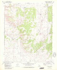
1979 Map of Metzger Tank
USGS Topo · Published 1980About this map
Kaibab National Forest dominates this high-altitude landscape in Coconino County, where the topography is defined by the ephemeral drainage of Coconino Wash and its various tributaries. The 1970s survey reveals a region specialized for ranching and water management in an arid environment, centered on the Gila and Salt River Meridian. Small-scale water infrastructure is the primary marker of human activity, with named livestock tanks such as Metzger Tank, Hole Sappo Tank, and Little Sun Moore Tank scattered across the township and range grid. These features, along with a network of jeep trails, highlight the area's use for grazing within the national forest system. The presence of the Water Tank Well and Little Well underscores the critical importance of reliable water sources for local land use and resource management during this era.
Find a feature on this map
21 named features on this map. Tap any name to fly to it.
Don’t see what you’re looking for? This feature index may not catch every label — zoom into the map to look around manually.
Map Details
Editions of this 1979 Metzger Tank Map
This is the sole edition of this map. No revisions or reprints were ever made.
Other maps of this area

1886 · Chino
USGS Topo · 1:250,000

1886 · Kaibab
USGS Topo · 1:250,000

1891 · Chino
USGS Topo · 1:250,000

1903 · Bright Angel
USGS Topo · 1:48,000

1906 · Bright Angel
USGS Topo · 1:48,000

1948 · Williams
USGS Topo · 1:250,000

1953 · Grand Canyon
USGS Topo · 1:250,000

1954 · Williams
USGS Topo · 1:250,000

1956 · Williams
USGS Topo · 1:250,000

1957 · Grand Canyon
USGS Topo · 1:250,000